Perth – Shark Bay
3 – 7 August
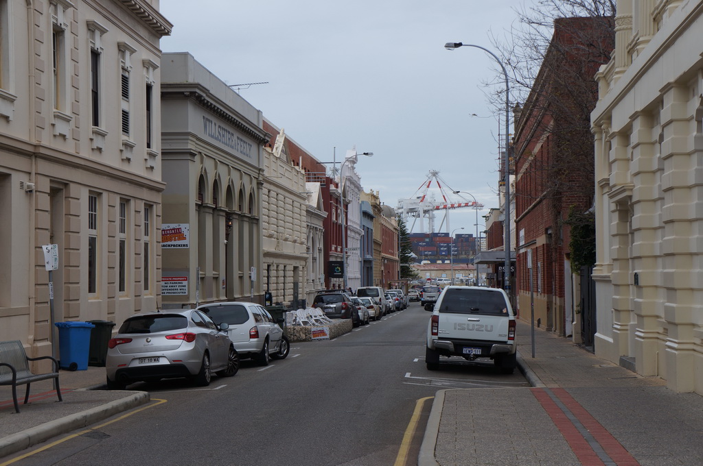
The car was packed, sandwiches made, goodbyes to our good Perth friends and it was time to head north, but first in true enTroopy style we took the freeway south to Freemantle. We’d already done the highlight tour of Freo sites when we visited Perth in 2011, but felt that we had missed out on having a wander amongst the old buildings of the suburb. After a meander through the streets and our last metropolitan coffee for what would be quite some time we headed north.
Our first port of call was The Pinnacles in Nambung NP some 200km north of Perth. Here limestone pillars some up to 4m high poke out of the yellow sand dunes. The experts think that because these pinnacles have been covered by shifting sands over time they were really only noticed in the 60s. It was quite odd, and the associated discovery centre wasn’t too much help in explaining how they formed – apparently the jury is still out.


Just down the road there was free council camping in the Southern Beekeepers Reserve. True to its name there was one of the largest hives we’d seen in a tree trunk. Needless to say we set up on the other side of the area next to the only other campers in for the night. We expected it to be much busier being the closest free camp spot to the Pinnacles, but maybe we need to be a bit further north to really be amongst the crowd.
We still weren’t able to shake the rain. We had the heaviest rain so far whilst driving as we headed into Geraldton, the largest city between Perth and Darwin. For the 2.5hr drive to Geraldton we counted 105 caravans and campers heading south in the other direction, and we were only on one of the two routes south for most of the drive. Don’t think we’ll be having campsites to ourselves any more! It seems like every man and his dog is up north, indeed it’s going to need a bit of a change of headspace planning ahead and booking sites.
We spent a bit of time looking around Geraldton including heading up to the HMAS Sydney II memorial on the hill overlooking the bay. In 1941 the Sydney was sunk whilst in a skirmish with a disguised German radar. Both ships sank but all 645 men on the Sydney were lost. They only found the wreck north west of Shark Bay in 2008.
We also headed to the Geraldton Museum which included an interesting Shipwrecks gallery. In particular they focused on dutch ship wrecks from the 17th century as they sailed the spice route to Batavia (modern day Jakarta). The most infamous of these was the ship Batavia which sank in 1629. A story that involves mishap – the ship struck a reef at the Abrolhos Islands;
bravery – the captain sailed with 47 other men in a longboat (essentially a large rowing boat with a mast) to get help from Batavia more than 900 nautical miles away;
tyranny – the remaining authoritative figure went ‘bat shit crazy’ murdering XX people in his quest to rule the survivors whilst banishing his rivals to a neighbouring island;
irony – the island to which the others were banished had better water and food supplies and they were able to withstand attacks;
and ultimately, justice – when the captain returned with help the good guys were able to get out to his boat first and explain what happened and he suitably dealt with the perpetrators of the crimes. It is quite some story and I don’t think I’ve really done it justice, so check out this link if you’re interested.
The museum had the story of how they discovered the Batavia wreck in 1963 and various relics they had collected from the wreck including canons, an astrolabe and the stones for a portico destined to grace the Batavia Palace. It was a very interesting place to spend a couple of hours.
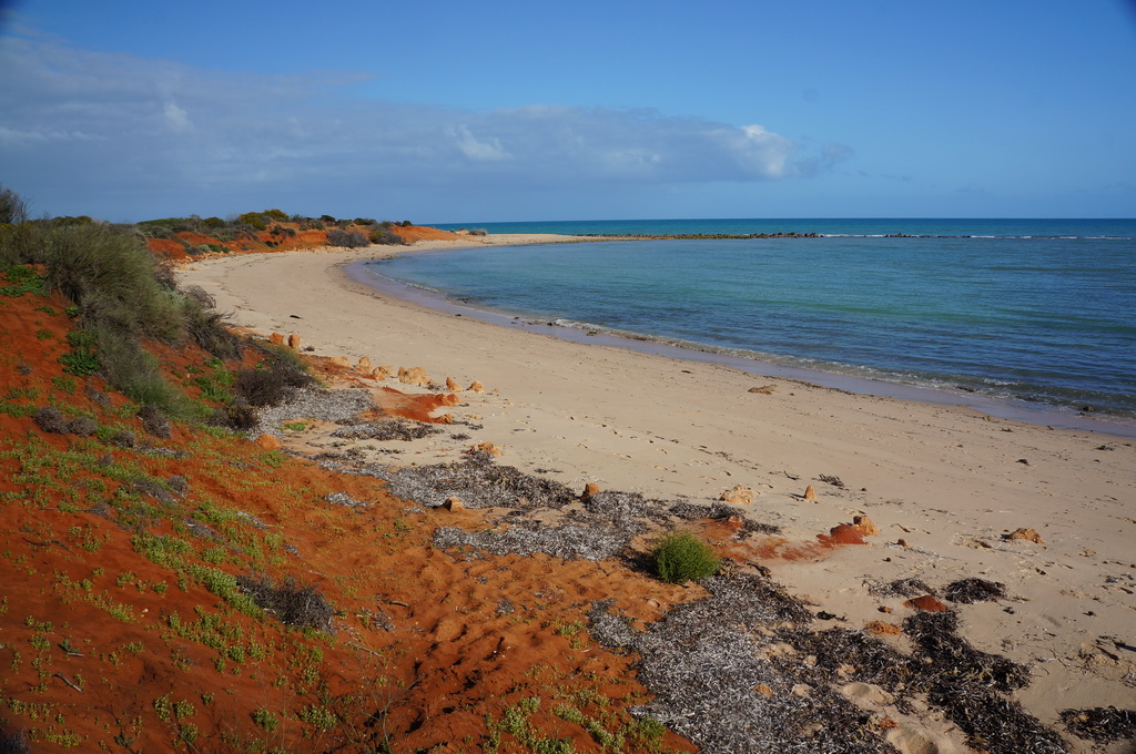
The next day up the coast we arrived at Kalbarri, the first taste of the red rocks and gorges of the north. Driving in along the coast the sun was shining and the contrast of the deep blue sea and red cliffs was striking. We climbed down to a formation called Mushroom Rock which didn’t quite live up to our imagined grandeurs but we enjoyed getting down the water’s edge. Then it was just around the corner to Red Bluff a distinctive red section of cliffs compared with the grey that is the norm for the surrounding coast. The early dutch sailors to the East Indies used to use them as a navigational aid.


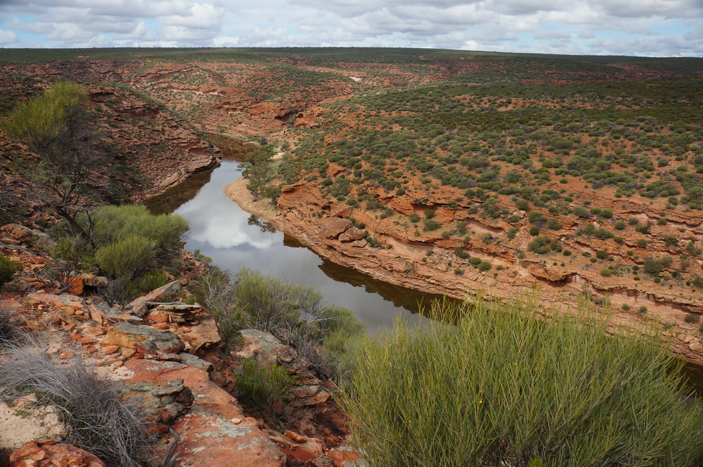

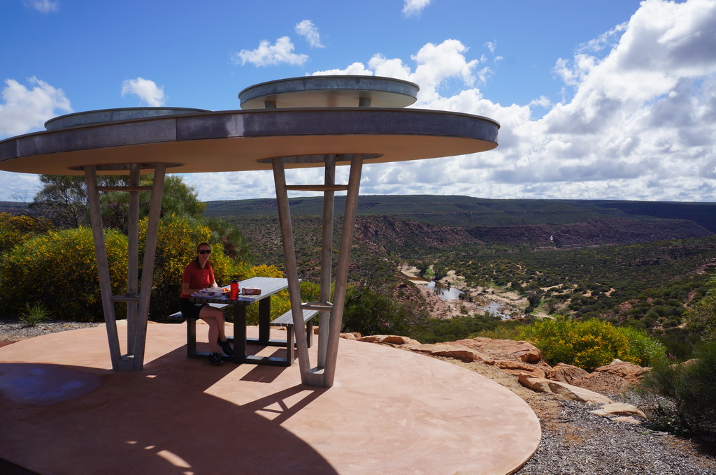


Whilst the coast is beautiful, Kalbarri is also known for the winding Murchison River that has cut a gorge up to 150m deep through the rolling scrub plains inland. So after a quick stop at the visitor centre in the township by a beautiful river mouth we headed along a rather corrugated road to a place called Nature’s Window. Here a natural window formed by a rock bridge structure frames a sweeping bend of the Murchison River. An almost full carpark, yip we aren’t in the deep cold south anymore Todo.
There is also an 8km loop walk that follows the river along the top of the gorge walls before dropping down along some rock ledges and along the sandy river bank back to the start. It was really good to get out and stretch our legs, although it was decidedly warmer – definitely shorts weather.
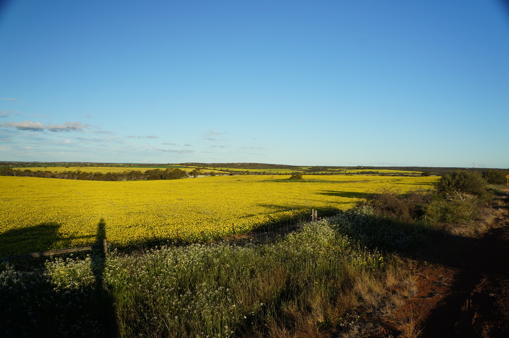
Spring is known as wildflower season in WA and we are fortunate enough to be hitting the start of it. Areas such as Kalbarri were starting to bloom with flowers of various colours and sizes springing to life. It was a treat to see pink, white and yellow flowers scattered through the rock ledges as we wandered the Murchison River, and we even managed to spot an orchid on the side of a trail. As we drove around one corner we were confident it was a field of Canola in the distance, however as we got closer we could see it was a pasture covered in yellow daisies – so striking that we had to pull over for a photo.
For the night we pulled into our first 24hr roadside rest area of the trip. Fortunately we picked one that was a bit nicer than just a patch of dirt by the side of the road with the area at Galena Bridge being offset from the roadway beside a pleasant river. Busy, busy, with a lot of caravans but I guess that is to be expected for a pleasant free campsite in this neck of the woods. We found a spot on the slightly less crowded side of the river and settled in for the night
Driving north towards Shark Bay the roads are lined with yellow flowering wattles / acacias, you can see why Australia adopted the colours of green and gold. Due to my grazes, my gear changing hand has been out of action, so Marcel has been doing all the driving with my duty being DJ as we are normally well outside of radio range.
Our next stop north was Shark Bay were a distinctive peninsula separates two bays. At a place called Hamelin Pool there are Stromatolites which are mineral formations create by blue-green algae. What makes this a unique place to visit is that Stromatolites are the earliest known lifeform, known to have been around 3 billion years ago, and still survive in small pockets today! Their biological process slowly generated most of the early oxygen in the atmosphere on planet earth which allowed other lifeforms to develop. We were there at low tide so could see the various different forms through the intertidal region and the shallow waters. The waters in Hamlin Pool are shallow, warm and almost twice as saline as normal sea water having conditions that still suit the blue-green algae. It was pretty neat gazing at the slightly unassuming blobs that are created by such an old lifeform.


On up the road, when suddenly the sun broke through the cloud, we could see the brilliant turquoise waters of the bay – wow! We drove on through Denham the only town in the area, and into Francois Peron NP on the northern part of the peninsula. It was time to let the tyre pressures down as we followed a sandy track up to our campsite at Gregories for the night. Following a wetting skiffy shower we were treated to the most brilliant rainbow I can remember – a full arc at its brightest with a complete reverse arc framing it all, what a treat.
Francois Peron park has areas of bright red sand / sandstone, and cream sand / limestone all bordered by the bright bluey-turquoise of the sea. It really is an incredibly picturesque place. We drove right up to Cape Peron, as well as to Skipjack’s lookout which, being elevated, lets you spot some of the abundant wildlife in the blue waters below, where we saw a dolphin and some rays. For lunch we headed to Herald’s Bight an idyllic white sandy bay where we pulled up mid-beach to enjoy our lunch of leftover nachos. It was really starting to heat up in the sun, so time to get paddling where with the clear waters we could see small sharks cruising by as well as rays with a shark-like tail – guess the bay had to earn its name somehow.
After bumping our way back out of the park we headed across to Monkey Mia a small resort based on the west side of the Peninsula. Monkey Mia is famous for its bottlenose dolphin feedings, where a handful of dolphins that live in the area come by for a controlled feed in the mornings. It is quite popular, and looking at the board ~250 people had shown up earlier in the day to be part of the first feed, which dropped off to ~100 for the second and third feeds throughout the morning.
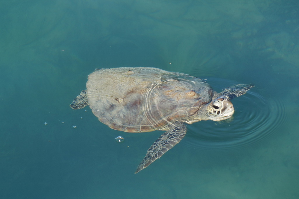
It was really relaxed down by the beach with a green turtle cruising around the jetty and the resident dolphins cruising up and down the beach. We shouted ourselves an ice-cream and enjoyed the peaceful setting. We tossed around the idea of staying overnight at the resort (camping of course – not going to completely blow the budget) so we’d be around for feeding that starts at 8am. In the end we decided to head back down the road to a beach camp at Fowler’s Bay and get a bit of a sleep in before another long drive north to Coral Bay and Ningaloo Reef.
E