Tom Price to Port Hedland
20 – 25 August
The closest town to Karijini National Park is a town called Tom Price, named after the mountain, which in turn was named after the chairman of an American steel company. The town came into being in the 60’s when the Iron ore mine there was opened up. Originally a Rio Tinto owned town, it is now owned by the local shire, but still has the classic mining town community feel to it.
Given our excellent experience at the Super Pit in Kalgoorlie we decided to go on the equivalent trip around the mining operations there. It was a weekend, so understandably quite quiet, however it didn’t seem much was going on. That may be in indication of the effect of the lower iron ore price, or simply of the sheer size of the mine there, they have 13 pits over its length with only 3 or 4 in operation at once. Over the past 50 years the mine has effectively cut the mountain in half to access the very high grade Hematite ore below. They have reduced the height of the landscape so much that it is no longer classified as a mountain. The tour took us to look at the main pit as well as the crushing, grading, blending and train loading operations. One of the coolest parts in my pinion was how they loaded the lump ore (ore about 30cm in size) into the Ore Cars of the train. The train runs underground under the big piles of ore, then a door opens under the pile allowing about 50 tonne of ore to fall into the car below.


In the late afternoon we headed up Mt Nameless (apparently they had run out of names, and didn’t bother to ask the local Aborigines who call it Jarndunmunha) for a bird’s eye view of the local area. It is the second highest pint in WA that you can drive up, and as expected the track was steep and it was definitely low range territory. The views over the mine, Tom Price township and across to the Hamersly Range by Karijini NP were fantastic.
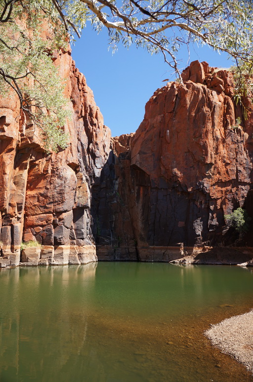
Over the next couple of days we were to follow the rail line out to the coast where the ore is loaded onto the ships on its way to China. For this we had to travel on a private Rio Tinto road which is used to maintain the railway line, and thus needed to get a permit from the Tom Price info centre and watch a typical mining induction video. After our quick detour to Hamersley Gorge we started our journey north-west towards Dampier. The road was as you would expect for a working road which is required to maintain the very important link between the mine and the port, very well maintained and easy to travel. We followed the road till it dropped us at the Millstream-Chichester National Park, a convenient stop about half way to the coast.
Millstream was an old station in the Pilbara which was based around some large water holes which now form the basis of the water supply to the coastal towns. The old homestead there sits close to one of the ponds of the station, surrounded by native palm trees. The station owners in the early days made the place feel more homely by adding water lilies, planting date palms and expansive vegie gardens in the microclimate created by the water. Now a lot of the introduced plants have been removed, but the place still has a very peaceful and pleasant feeling about it. The other water hole close by was called Deep Reach due to its very large size, again lined with river gums and palm trees its water was cold, but very welcome for a swim given it was a very hot day. The camp site that night was called ‘Stargazers’, and boy did it live up to its name. The moon was waning, so we had a good couple of hours of staring at the Milky Way before the moon spoilt our fun.
On the way out of the park we stopped in on Python Pool, another permanent water hole nestled at the base of some cliffs in the Chichester ranges. What made this side trip special were the hundreds of bright red Sturt Desert Pea flowers lining the road. This is the state flower of South Australia, however we didn’t get to see any when we were there so it was nice to be able to have a good look at them later in the trip. Continuing along the road towards the coast we crossed the rail a couple more times having to wait for the 2.5km long trains to pass, but then catching up to them again as they only travel about 70km/hr, until we reached the main road north along the coast just outside Karratha where our permit ran out. We did intend on going into Karratha to go check out the old haunts I had ‘grown to love’ in my time there about a year ago, but that was for tomorrow, today we were off to Point Samson to catch up with some work mates who were up at Cape Lambert for another project.


Point Samson was a nice little town, a small community of houses, a tavern and a couple of caravan parks by the beach. The beach was an interesting one, we went for a swim the afternoon we arrived and walked out into the water as you do, expecting for it to get deeper until a point where you can actually swim, but after 50m it was still only at knee deep. At 100m from shore, still knee deep. Turns out that the little bay completely empties out at low tide and is pretty much flat for a couple of hundred meters. Round from the swimming beach it must have been a bit deeper as there were a few juvenile humpbacks swimming around quite close to shore. That evening three work mates came down to the tavern from their camp to meet up with us for dinner. It was really great to be able to catch up with them and hear about what had been happening back at work in Melbourne. The next morning we awoke to a couple of plastic bags tied to the rear bar of our vehicle, turns out they had returned early that morning to drop us off a care package of food from camp to help fatten me up, apparently I had lost weight since they last saw me four months ago.
The tour of Karratha started early the next day with a visit to the Karratha LIA (Light Industrial Area) to get a tyre fixed, then it was out to Dampier, stopping by the statue of Red Dog, a Kelpie who wandered the Pilbara in the 70’s and became a living legend. We then headed down to the northwest shelf gas plant and spent some time in there visitor centre learning about the processes required to turn natural gas into LNG. What I found most impressive is that they had absolutely massive tanks sitting on site filled with LNG sitting at negative 161 degrees, waiting to be loaded onto special ships to transport the fuel to Japan.
Back in Dampier we stopped in at the Mermaid bar for a beer overlooking the beautiful harbour of Dampier with the noise of the iron ore ships being loaded in the background. I had never quite appreciated how nice it was down on the Dampier foreshore. Back towards Karratha we stopped off at 7 Mile, the railway siding where we installed the Workshop for Rio a year ago so Estelle could see where I spent most of my time, then off to the Karratha Tavern for another beer. The evening culminated in meeting up with another couple of guys from work who were still in Karratha supporting the operation of the workshop, spent another evening catching up on news back home and reminiscing.


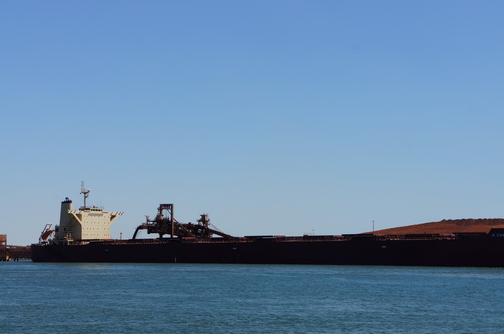


The next day we had a very long drive to try and get up close to Broome, so we started off the day with a walk up the top of the hill next to town for a lookout and to look at some old aboriginal rock engravings, before running some last errands and having a coffee in town. The next stop on the journey was Port Hedland, another Iron ore port used by BHP, FMG and Roy Hill for their export facilities. As opposed to Karratha, the iron ore operations there are very in your face. Down at the port in the old part of town you are able to get quite close to the massive ships being loaded with the hundreds of thousands of tonnes of ore on their way to China. It was a fitting end to our Iron Ore trail through the Pilbara.
M